Research
Performative nature
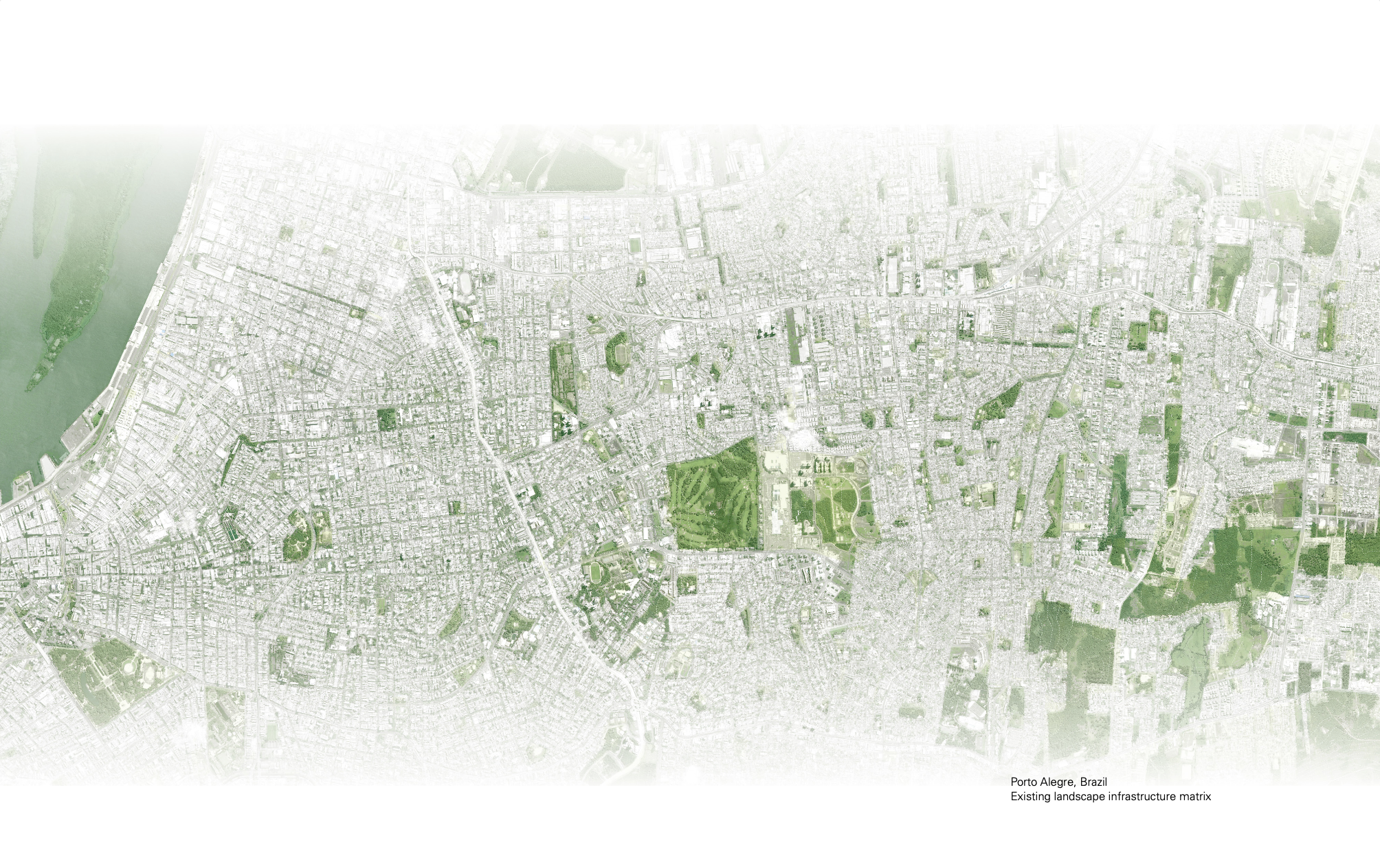
Urban landscape infrastructure design in water sensitive cities
[2010-2015]
Doctoral Research
[2010-2015]
Doctoral Research
Bacchin, T.K. (2015). Performative nature. Urban Landscape infrastructure design in water sensitive cities. PhD dissertation. A+BE | Architecture and the Built Environment.
![]()
![]()
![]()
![]()
![]()
![]()
![]()
![]()
![]()
![]()
![]()
![]()
![]()
The objective of the research is to assist the process of designing/ retrofitting the urban ground for water sensitivity. This is developed considering stormwater management as an urban landscape infrastructural project. The interplay between landscape architecture and (storm) water engineering is sought for the gradual renewal of biophysical processes – in articulation with cultural identity and practices aiming to help avoid maladaptation.


Preface
The 21st century urbanisation questions the ability to orientate ourselves in a landscape of risk, defined by the impacts of increasing human activity in a complex relationship with nature. A tale of deep uncertainties, regarding both environmental and socio-economic conditions, reflected into a growing awareness about the need to prevent irreversible ecosystem harm (UN 1992; Miller & Westra 2002). Within this context, managing urban water is of critical relevance and flood risk represents one of the most urgent challenges for urban prosperity and survival. Planning a healthier/ resilient urban water environment (Baker et al. 2009) means to develop strategies that are able to better operationalise the relation between natural and man-made systems.As noted by several scholars (e.g. Alberti 2005; Tucci 2003), the spatial distribution of flood risk is an outcome of this relationship between urbanisation and nature. Namely, land use/ land cover patterns alter water processes and the likelihood of hydrogeological hazards. Scale (extent and grain) of urbanisation delineates the impact of these hazards: to what degree they are mitigated by the buffering capacity of natural/ semi-natural areas in both urban and surrounding rural areas. Recurrent direct and indirect damages –social and economic disruptions caused by floods – have an effect on how investments can be insured or re-insured. In other words, they define the costs of doing nothing. In Brazil, floods are considered one of the key obstacle to socio-economic development. According to Swiss Re (2011:2) “the population exposed to flood risk is likely to surge from 33 million today (2011) to 43 million by 2030. The annual expected losses are estimated to rise from USD 1.4 billion to USD 4 billion.” Flood risk is a particular threat where universal access to infrastructure, public services and basic liveability standards are yet to be ensured (UN 2015). Thereby, in the Brazilian context (and not only) the pressing question is how the urban project could address both risk and inequality (Lefebvre 1968; Mitchell 2003; Sen 2009).
The increase in extreme rainfall events (Lehmann et al. 2015; IPCC 2014) requires a better understanding of the dynamic relationship between land and water systems. Retrofitting the existing built environment for flood risk reduction requires an unprecedented effort to articulate radical and yet sound strategies able to deliver urban water performance along with additional ecological, spatial, and socio-economic values. As noted by Secchi & Viganò (2011), to reflect on the landscape of the 21st century means to be confronted with the challenge of uncertainty (the awareness of) and this must mobilize our collective knowledge and imaginative capacities. In the ongoing debate about planning and design practice (e.g. Reed in Waldheim 2006), adaptation, appropriation and flexibility became the desirable values to be built within systems while providing liveable urban environments.
New ideas (e.g. Novotny et al. 2010; Wong and Brown 2009), for the integration between planning, design and engineering disciplines is establishing the role of landscape architecture (structural qualities and processes) in the project of urban water. This integration is bridging infrastructure and urban (landscape) design through the concept of multifunctionality: infrastructure that is not any more engineered for a single purpose. As stated by Hill (2009), there is no longer doubt that the design of soft (green/ blue) as an alternative approach to conventional hard (grey) infrastructure can function. Yet, its successful delivery is a matter of design/ engineering and the institutional frameworks in place.
Scientific problem
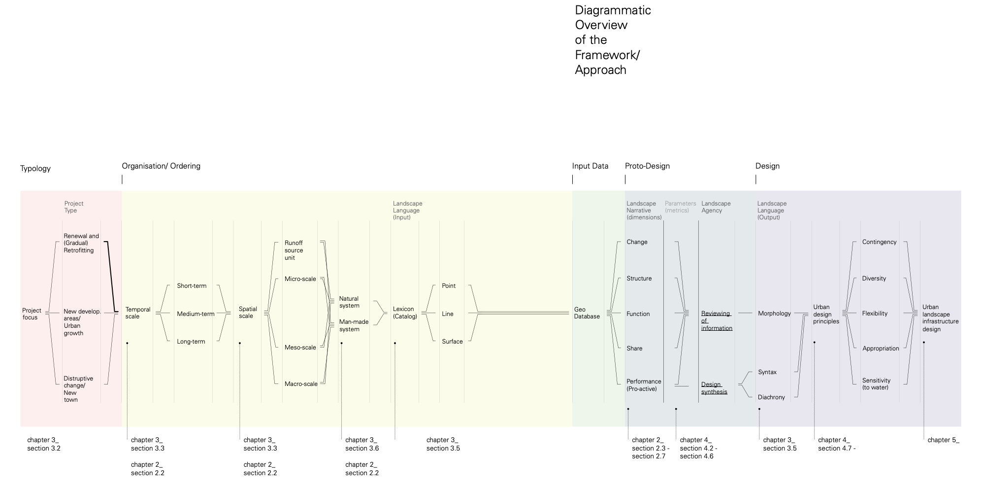
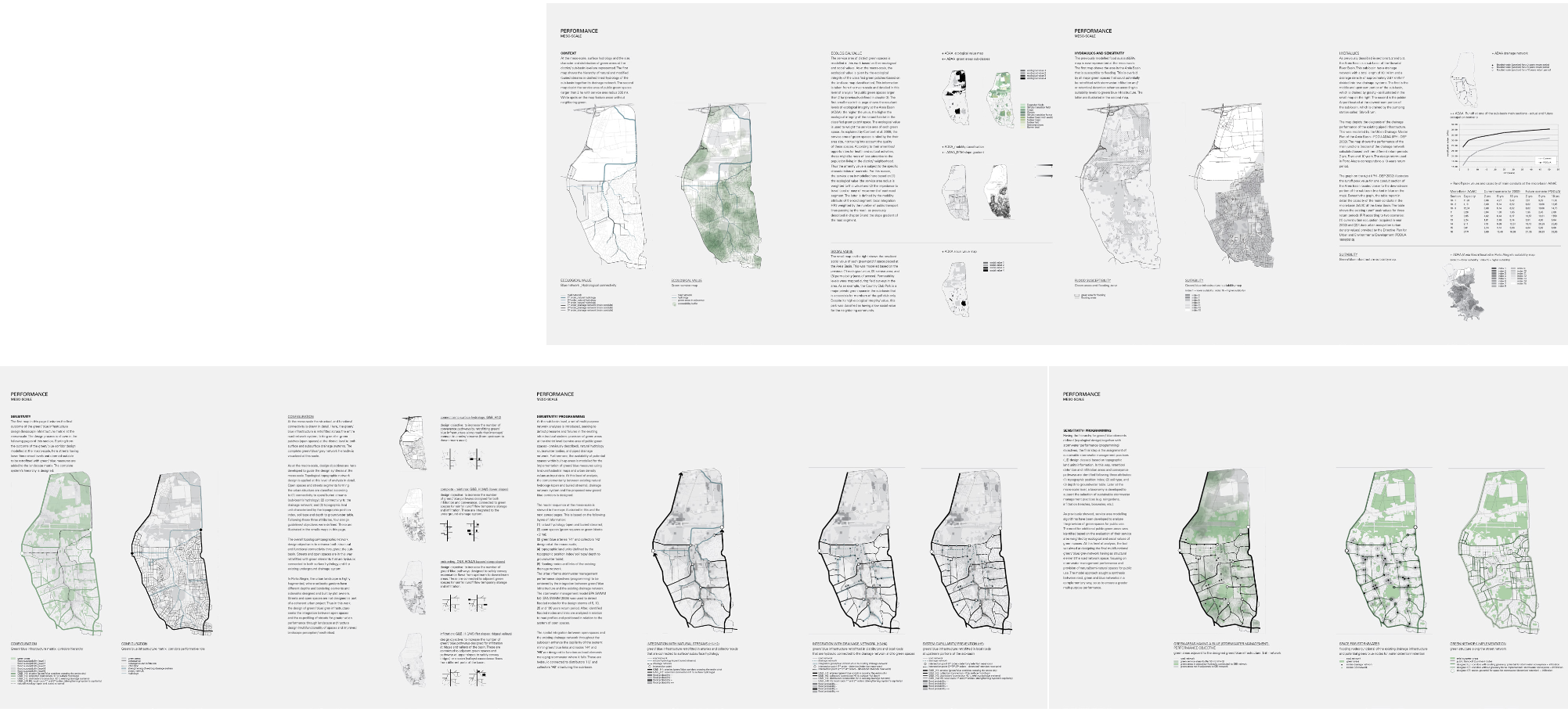
From a design/ engineering perspective, the question is how to design for contingency and multifunctionality, managing or adapting to events as they unfold in time, with in-built flexibility, and at the same time providing elements of permanence for cultural appropriation. This leads to both quantitative and qualitative aspects, i.e. to the ability of a site to manage flows in time while producing experiences and identity. Instrumental to these aspects is the topological understanding of the urban landscape to articulate the design in a systemic way for both landscape functional performance and visual perception – as an intelligible whole (Girot 2006; Hillier 1996).In a geographical sense, as argued by Bélanger (2013), the physical/ fluid extents of risk that are emerging as a result of the inevitable effects of anthropogenic impacts do not coincide with political borders. Hence, to manage flood risk within and across regions requires a shift of perspective regarding our regulatory, planning and design systems: one that enables the delineation of areas based on common challenges and potentialities. If our own patterns of urbanisation are directly related with the ongoing processes of hydrogeological distress, possible pathways (Haasnoot et al 2013) to flood risk management could be traced by exploring and sequencing a set of spatial morphologies that are sensitive (i.e. responsive) to urban water within common biophysical land units (Zonneveld 1989). Here, topological-topographic design functions as the structural and operational field relating the urban fabric to biophysical flows across different regions and scales – defining a landscape matrix of nested physical layers for water resilience.
The agency of ecological processes in the design of urban infrastructure (Bélanger 2009; Waldheim 2006; Reed 2006) introduces a more integral form of landscape architecture where, as stated by Corner (2014:75)
“(…) the central interest is the fundamental manner in which the entire site is treated as a large-scale landscape, as a kind of tissue and bonding agent that ties all the disparate parts together. Corridors, patches, mosaics, bridges, pathways, landforms, and matrices create a fabric within which the city can grow new roots.”
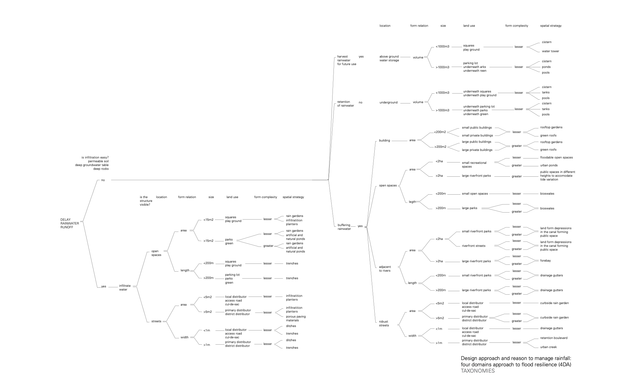
In the case of urban water environments, this hybridization between landscape and infrastructure takes the legacy of existing man-made drainage systems in the urban fabric and its’ retrofitting with soft (green/ blue) devices for infiltration, conveyance, retention/ detention, evapotranspiration and use of rainwater. Roofs and inner gardens, setback gardens, sidewalks, roadways, parking lots and public open spaces are in this way retrofitted to reduce runoff volume, peak discharge and time of concentration; at the same time filtering pollutants before they are discharged to the existing
man-made drainage system and/ or directly to water bodies. In doing so, the single functional performance of open spaces and buildings can be improved, as shown by several projects that were successfully implemented worldwide (e.g. in Portland, USA; Hamburg, Germany; Lodz, Poland; Rotterdam, Netherlands; Melbourne, Australia as described in Hoyer et al. 2011).
However, the topological-topographic (network) design through scales determining where to place green/ blue devices, balancing the size of these elements according to their connectivity and performance criteria is yet to be further explored in research and practice. Furthermore, a greater network of green/ blue spaces for stormwater management can enhance provision and access to natural areas in highly urbanized environments where these have been reduced over time. The implication of this systemic approach is to consider the need to improve functional infrastructure performance as an opportunity to design a more coherent, liveable and therefore responsive urban environment.
A new disciplinary synthesis is required to reflect on the agency of infrastructure design as a catalyst of socio-cultural change and as an instrument for water resilience. The infrastructural project, originally restricted to the domains of engineering, ecology, or regional planning, is increasingly being programmed and articulated through design disciplines (e.g. Sijmons 2014; Hung and Aquino 2013; Palmboom 2010) – opening a new range of formal and technical possibilities and values.
Challenges are many when envisioning these changes as part of a comprehensive urban project taking into consideration several actions across scales (Zevenbergen et al. 2008). Therefore, the novel research presented here aims at answering the following question.